Helena Zdráhalová • foto: Wikimedia Commons, Urban and Regional Laboratory • 15 October 2013
Do you know where you live? Faculty of Science exhibition describes urban changes over the years
How has city life been developing and changing in the last few years, what changes have taken place in the number and age or nationality structure of the population and which areas are considered dangerous by the local population? These are only a few of the many questions for which scientists from the Urban and Regional Laboratory (URRlab) of the CU Faculty of Science are seeking answers. Selected results of their research will be presented from 17 October at an exhibition entitled Social Deprivation in the Urban Environment at the faculty building at Albertov in Prague.

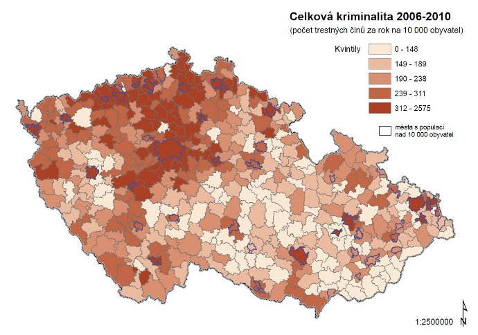
One of the maps that visitors to the exhibition can see; this one describes the number of criminal offenses committed in various parts of the country
The exhibition was preceded by a four-year project of the Czech Science Foundation, realised by the URRlab team at the Department of Social Geography and Regional Development of the Faculty of Science. “The exhibition takes a look at various aspects of social deprivation in Czech towns and cities, changes in localities and the daily rhythm of towns and cities and the life of senior citizens in towns and cities, as well as mobility and commuting. We also address specific topics such as counter-urbanisation (the migration of people from towns to the countryside – Ed.). The exhibition addresses a truly wide range of phenomena,” added Mgr. Jana Jíchová from the Urban and Regional Laboratory.
Visitors to the exhibition can look forward to seventeen panels full of information, maps, pictures and graphs. The exhibition will also include a collection of themed publication and the presentation of two online projects run by the laboratory. The first of these is the so-called Atlas obyvatelstva (Population Atlas), a website dedicated to the publishing of maps on populations and their movement, quality of life, housing and settlement. The second project is the website suburbanizace.cz (Czech only), where researchers present the results of their research into suburbanisation.

One of the maps that visitors to the exhibition can see; this one describes the number of criminal offenses committed in various parts of the country
“The exhibition is aimed at both scientists and students of (not only) urban studies, as well as the wider public. Visitors to the exhibition will see a large number of studies addressing, for example, the very localities in which they live, so they can know their town or city from a slightly different point of view. We hope that our work can also inspire people at town halls and local authorities,” emphasised Jíchová.
The exhibition, located in the foyer of the Geographical Library of the Faculty of Science, will be open from 17 October until 22 November. Entry is free of charge. Once the exhibition is finished, the team will offer the exhibition on loan to non-commercial institutions addressing changes in towns and municipalities.
